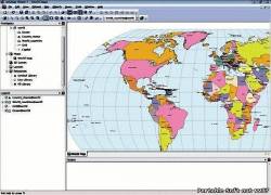
 AvisMap GIS Deskpro has friendly and simple user interfaces, with which the user can
easily browse, edit, query, output the spatial data and process spatial analysis, 3D modeling, connect to large-scale spatial databases. It is an ideal choice for GIS data processing. AvisMap Desktop Professional 5 is a professional desktop GIS software for map editing, managing, analysis attribute data, aid decision-making transactions and output map, print tables, 3D modeling, and other functions.
AvisMap GIS Deskpro имеет простой и дружественный пользовательский интерфейс, с помощью которого пользователь может легко просматривать, редактировать, запрашивать, выводить пространственные данные процессов пространственного анализа, 3D моделирование, подключаться к крупномасштабной пространственной базе данных. Это идеальный выбор для обработки данных GIS. AvisMap Desktop Professional 5 профессиональное GIS программное обеспечение для редактирования карт, управления, анализа данных атрибутов, содействия процессу принятия решений операции и вывода карт, печать таблиц, 3D моделирование, а также другие функции.
Как инструмент управления полным анализом, AvisMap Despro 5 применимо в области землепользования, лесного хозяйства, электроэнергетики, телекоммуникаций, транспорта, сеть городе труба, управление ресурсами, анализ окружающей среды, туризма, ирригация, воздухоплаванию, военной и других областях, которые требуют карт обработка . As a complete analysis management tool, AvisMap Despro 5 is applicable in land management, forestry, electric power, telecom, traffic, city pipe network, resource management, environmental analysis, tourism, irrigation, aeronautics, military, and other fields that require map processing. The Main Characteristics
Multiple Database
Multiple databases can be used in AvisMap GIS such as Oracle, SQL Server. Vector and Raster Data
AvisMap GIS has a perfect database construction, which can store vector and raster data in the same datasource at the same time without separation. Topology Storage
The datasource in AvisMap GIS database can store network topological relationship, which stores a network dataset into a database. Long Transaction
AvisMap SDM 5 has long transaction processing function which can processing in a long time without any influence. Transaction is an important function in GIS software, which includes long transaction and general transaction. General transaction is supported by DBMS, directly used in AvisMap GIS SDM +5. However, there are some slight difference in DBMS application with GIS program such as vast processing data volume in the first edit; and long edit — for several days, months or even longer; allows others to browse correlation data during editing, which requires long transaction. AvisMap GIS has long transaction with characteristics shown below:
* After starting a long transaction, other users can only browse data before editing in lock room rather than editing situation after locked or process editing locked data;
* Long transaction can persist for several days, months or even longer without any particular processing and can be continuous any time;
* Modification in long transaction is quite safe. The edited data will not be lost or damaged even though in sudden power turnoff, crash or other unforeseen, catastrophic event;
* At any time, if you are not satisfied with the changes, you can undo them and recover before locked;
* When you submit the modified version while completing the edit,other users will receive it immediately;
* Other users only can modify in locked room after you submit or undo your modification.
* Adopt Compounded Multilevel Index Technique
* Optional File Buffer Memory
For different levels data, it adopts different buffer mode for improving efficient. File buffer memory stores data which has been accessed for the first time as a temporary file into local disk. The speed of the data fetch will be rapid afterwards. File buffer memory occupies more disk space.
* Vector Data Destructive/Nondestructive Compression
Compression can slash data capacity and fast access speed. AvisMap SDM 5 adds destructive compress mode based on original vector nondestructive compression. This special compression model will only lose one billionth of data precision when the data size is compressed to half of the original size.
* Image Compression
AvisMap SDM 5 improves image compression algorithm and increases the compression ratio by a large margin.
* Sequential Data
AvisMap SDM 5 stores the whole data history for convenient tracing of data in the past, and can even playback the changes of the historical data.
* Optimization Edit Operation
The optimization data editing makes the work more convenient which improves the efficiency for editing. Operating systems supported by all AvisMap products:
* Windows 7
* Windows Vista
* Windows 2000 with SP2 or later,
* Windows NT4.0 with SP4 or later, IE5.0,
* Windows XP with SP2 or later,
* Windows Server 2003 with SP1 or later Update: Nov, 2009 Languages: English Licence: Freeware Developer: Home page The program is registered Size: 29.7 Mb
|